Minimise cost & risk
Simultaneously save money while minimising the traditional risks presented to surveying teams.
Simultaneously save money while minimising the traditional risks presented to surveying teams.
TUV tested to guarantee a safe and reliable flight in any weather conditions.
Easily transfer land survey data to any digital asset management system for further analysis.
Get an accurate analysis of the land and material volumes from the sky in a fraction of the time.
Geometrically corrected aerial photographs are overlaid on a uniform map to provide operators with a comprehensive map free of distortion.
The overlaid photographs allow for the display cultural and land characteristics, instead of representing those features using symbols and lines.
The integrated map gives an accurate representation, making it helpful to measure true distances and to get a real-time land map overview.
Efficient solutions are made by mapping reserves, stockpiles, mines and parks using technology like orthomosaics and point clouds mosaic images.
Creating 3D models of sites and materials using drones is faster and more affordable than traditional methods done on foot.
Calculating the amount of resources, such as coal, logs or iron ore, is much faster and more accurate with drones than with traditional methods performed using lasers or helicopters.
Creating 3D models of sites and materials using drones is faster and more affordable than traditional methods done on foot.
Tested and certified to operate without fault inside of electromagnetic fields.
Guaranteed to keep important electrical components and data protected from heavy rain and dust.
Experienced staff can assist with implementation and legal advice to get you started.
Get extensive theoretical, practical or short refreshment training on flying the Altura Zenith.
Experts provide inspections, re-calibrations, software updates and operational assistance.
Customise your Altura system with the correct sensors and accessories to satisfy your needs.
| Fly the Zenith starting from* |
EUR 21,990.00 |
*Prices communicated in this list may be subject to change |
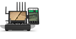
GCS + HD link

1 Battery + charger
Tested aircraft system

Gimbal + Control cable
Rugged transport case
